|
|
 |
|
|||||||||||

Boston planners can learn a lot from the good, bad, and ugly of San Francisco public spaces By Robert Campbell, Globe Correspondent, 5/14/2002 Last in a series examining how other cities have confronted planning challenges akin to the development of the land over the Central Artery. SAN FRANCISCO -- This town is Boston's alter ego on the other coast. The two cities have much in common, including residents who take an intense interest in urban design. Like Boston, San Francisco suffered from a despised overhead expressway that ran along its downtown waterfront. As Boston is about to do with its Central Artery, San Francisco tore down its expressway. Both cities, therefore, have had to deal with the same huge question: What do you do with the space where the expressway used to be? San Franciscans had some help from a 1989 earthquake in removing their expressway, known as the Embarcadero Freeway. And they didn't build a new one underground, as we're doing. So the two cases aren't identical. But in both cities there's a strip of new land, parallel to the water, about 1 1/2 miles long. There's a lot to be learned from things that San Francisco has tried, some good and some not so good.
What did San Francisco get right in its new open space? Here are some examples:
Like the new restaurant that helped rescue Bryant Park in Manhattan from the druggies who used to dominate it, the restaurants here will enliven the park, and they'll also spill people out along the waterfront for an after-dinner stroll. The park is being financed by the Gap, which has its world headquarters across the street and has shown the good taste not to cheapen the park by naming it after the company. It will be Rincon Park, a historic San Francisco name. The designer is noted landscape architect Laurie Olin, one of the outside experts who will speak at the Boston town meeting.
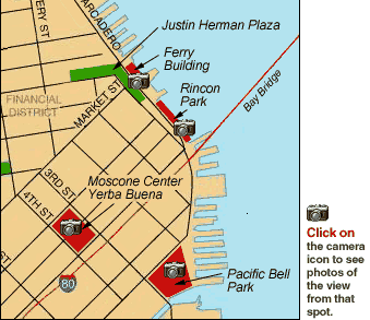
Now for some things that don't work so well: First, the empty green space. I was shocked when I walked along the waterfront on a warm, sunny Sunday afternoon in late April and found so few people there. A major green park, called Justin Herman Plaza, was being used by only six people. Two were sleeping homeless men and two were teen skateboarders. This park has existed since the days when the freeway ran past it, which may taint people's perception. It suffers from a complete lack of activity generators, such as those future restaurants in Rincon Park, and also boasts what must be the world's most aggressively ugly piece of sculpture. Few people live nearby. Justin Herman Plaza is the poster child for the argument that people will use a park if it's on the way to something, if it contains an attraction, or if it's near home -- and otherwise probably they won't.
The plaza has no reason to exist and draws no visitors. The Ferry Building is now being fully renovated and will soon contain a farmer's market and food court, which should help. And a small hotel is planned nearby. But nothing is going to animate this plaza. It's an example of a mind-set that says pedestrian open space is always better than streets, a view probably caused by the fact that traffic engineers have ruined so many streets by turning them into little more than sewers for traffic. In any good city, some of the best public spaces are streets. Think of Commonwealth Avenue. The one street that remains at the Ferry Building, running parallel to the water, offers Boston a further warning. A proposed parking lane, which would have slowed the traffic and humanized this street, has instead been converted into an extra traffic lane, creating an "efficient" high-speed traffic sewer. The streets on either side of Boston's artery land are supposed to consist of two traffic lanes and one parking lane. We'll see. Also problematic in San Francisco is another stretch of empty paved space. From the Ferry Building almost to PacBell, a mile or so in length, the waterfront is handled in a single uniform manner. It's just one long concrete walk with a concrete fence, overlooking the water of the harbor. A misguided work of public art, called the Ribbon Project, merely adds an endless ribbon of more concrete. There's nothing on the water side of the walk. In the past, the shore was lined with shipping piers, but they've now been removed. In one place, the rotting posts of a former pier have been allowed to remain as a memory, and they're about the most interesting thing that happens. The only people who seem to use this empty, long walk are joggers. My speculation is that San Franciscans have overreacted to the tourist consumerism of places such as Fisherman's Wharf, on the far side of the Ferry Building, and therefore they've chosen emptiness here. The waterfront would be a more interesting place if some activity, perhaps public boating or a floating concert pavilion, is allowed to attach itself to the walk. Besides the waterfront, there's one other place in San Francisco that deserves mention. It's Yerba Buena, a cluster of museums and other cultural attractions around a rolling green park that is actually the roof of the city's underground convention center. Last year, no fewer than 270 outdoor events -- performances, concerts, exhibits of all kinds -- were programmed in the park. Yerba Buena, which was first planned in the 1970s, also includes hotels and 3,750 apartments, half of them affordable. That happened because, as the museums and convention center raised the value of the surrounding real estate, the redevelopment authority sold parcels for private development in order to finance further growth of the public institutions. Yerba Buena is the perfect example of three things: the power of long-range integrated planning, the need to feed a public space with activity from its edges, and the importance of programmed activity to give richness to the life of that space. It's also an example of the need for maintenance: $2.5 million a year are spent, including full-time security. The rules from San Francisco on how to make good public space? Here are nine to at least argue over, as we think through Boston's historic Central Artery opportunity: 1. Get someone to run the place. In San Francisco, the city itself takes charge of the waterfront. Yerba Buena has its own redevelopment authority. It takes long-term commitment to create the best places, and that means somebody has to be responsible, someone who can listen to the voices of a populist democracy but also overrule some of them when appropriate. Boston's artery space, by contrast, is after many years still a bone of contention between the city and the state. 2. Don't kid yourself that people will come to an open space, green or paved, just because it's there. Create generators of activity. They may be permanent cultural or commercial fixtures, or they may be short-term programmed activities. 3. Pack the edges of the open space with housing. 4. Don't be afraid of commerce. Commerce is why cities exist, and it's part of their lifeblood. People like to go to ball games, grab a coffee or a beer, buy tickets to a concert, or take a boat ride. 5. Watch out for public art. Nobody seems to know how to make it anymore. 6. Don't let traffic experts kill a parking lane. 7. Find the "memory in the site." 8. Remember that the better the public transit, the more successful the public space. 9. Have some fun. Be inventive. Try things. Even Portuguese water dogs.
Robert Campbell's e-mail address is [email protected].
|
||||||||||||
|
|
||||||||||||
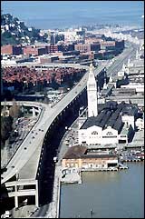 The elevated Embarcadero Freeway once ran directly in front of the Ferry Building. (Roma Design Group photo)
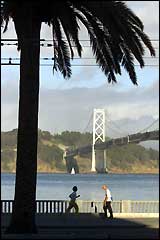 Along some stretches of the San Francisco waterfront, joggers are among the few people to be seen. (AP photo)
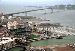 Pacific Bell Park, where the San Francisco Giants play, is a lively addition to the city's waterfront. Some of the park's bars stay open even when there's no baseball game. (AP photo)