direct flight
New technology will guide planes
By Matthew Brelis, Globe Staff
Call 1999 the year of airline passenger discontent.
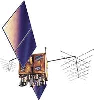 A satellite-based system will let commercial jets avoid zig-zag routes required by ground-based navigation. Planes will be able to use Global Positioning System satellites to accurately determine their position and altitude.
|
Fliers have vented their anger at airlines over long delays, tepid service, and worrisome safety issues; the carriers, in turn, have pointed accusatory fingers at the Federal Aviation Administration.
But the industry and the FAA are working together to fix the problems with the help of technology that will change the way airplanes move through the nation's skies and how passengers move through airport terminals.
This past summer, two new high-tech navigation systems dependent on GPS were tested and they worked well. That means 2000 might be the year that computers and satellites start to bring spiraling passenger frustrations back to Earth.
GPS, or global positioning system, uses a network of satellites orbiting the Earth for navigation. But because the satellites are not 100 percent accurate for civilian use (the Department of Defense insisted on built-in errors for security purposes) the FAA (www.faa.gov) and airlines are augmenting the system by building a network of ground-based reference stations that will still preserve the military's security and enhance the accuracy of the civilian system. The last of 25 stations that comprise the backbone of the so-called Wide Area Augmentation System, or WAAS, was completed last year.
When WAAS becomes operational, probably next September, a pilot will be able to determine the airplane's veritical and horizontal position within six or seven meters (about 20 to 23 feet), compared to 100 meters (328 feet) with normal GPS. The current system of radio-based navigation is accurate to within about one mile.
Under the current system of navigation, pilots must fly a rather zig-zag course in order to pass over ground-based navigation aids such as radio beacons so that they know they are on course and human flight controllers can track them.
With WAAS, pilots will be able to fly in a straight line from their origin to their destination; there will be no need to pass over radio beacons on the ground because the plane will be tracked by satellites in the air.
By flying a more direct route, planes should arrive on time more frequently. The accuracy of the system should also allow more planes in the air with less space separating them. For example, flights over the ocean - where radio beacon navigation aids and radar coverage are virtually non-existent - are separated by at least 60 miles today. Under GPS, that could be reduced significantly.
In addition to WAAS, a Local Area Augmentation System, or LAAS, will use a series of small networks of receivers on the ground and a pseudo-satellite - a small device on the ground that appears to be a satellite to the plane's navigation system - called a ''pseudolite'' so planes will have accurate information within 30 miles of an airport. The system increases the usability of GPS so if not all satellites are in view, or one is malfunctioning, planes will still be able to land in bad weather. Pseudolites will permit planes to land in dense fog and visibility of 150 feet.
At Logan International Airport in Boston (www.massport.com/logan), for example, there is one runway that has a very accurate instrument landing system that uses radio frequencies to direct a plane to the center line of the runway and then to the landing point.
The Logan system lets a plane land in bad weather with 600 feet of visibility ahead, and guides it to within 50 feet of the ground. If the pilot cannot see the runway at that point, the landing should be aborted. With pseudolites, landings can be done with 150 feet of forward visibility, and planes can touch down without the pilot seeing the runway. ''Massport will certainly lobby the FAA to get pseudolites on line when they are available,'' said Massport spokesman Jose Juves.
Another successful test last summer involved advanced anti-collision equipment that would not only enhance efficiency by safely allowing more planes into the same airspace, but also reduce the threat of runway accidents between airplanes and between vehicles and airplanes.
The system, known as ADS-B, for automatic dependent surveillance-broadcast, sends out accurate position information, along with speed, direction heading, and identification data to other planes or vehicles with similar equipment using a digital datalink. In the test, some 24 planes and one van equipped with ADS-B were able to identify other planes. The system is expected to greatly improve the efficiency of airport arrivals and departures.
''We truly believe ADS-B technology is essential to streamline and modernize the National Airspace System and will become an essential tool to keep our skies safe and more effienctly managed in the near future,'' said Steve Alterman, resident of the Cargo Airline Association, which co-sponsored the tests.
And what about those frustrations in the terminal? Airlines are turning to technology here as well.
In September, United Airlines (www.ual.com) announced that it will begin using state-of-the-art model ''chariots'' at all of its hub airports. The battery-powered remote workstations will enable customer service representatives to set up portable ticket counters anywhere in the airport to issue tickets and boarding passes and to check luggage - thereby reducing long lines at the traditional ticket counters.
Delta Airlines (www.delta-air.com) recently announced a new computer boarding system that provides more information from lists of passengers on standby to the status of connecting flights. Airline officials say that should accelerate the boarding process, reduce delays, and free up agents from answering questions so they can spend more time on other passenger services.
The airline is also using the equivalent of ATMs where shuttle passengers can check in and obtain boarding cards.
Matthew Brelis ([email protected]) covers the airline industry for the Globe.